For many of us, cartography day in geography or history class meant a quick nap. With our eyes open, we’d dream of all the delicious stuff we were gonna eat after school, of music we’d play on the Walkman, of a message we received the other day from that cutie…
To bring back our long-lost excitement for hard pieces of data, aka maps, plans, and geographic drawings, we’re gonna need to start from the very best of them. Luckily, there’s a whole online community on Reddit dedicated to the most unusual charts of geographic areas that took maps to a whole new level.
From mapping “October” in European languages to mapping an eagle’s track over a period of twenty years, these incredible examples will surely put the world into a completely new perspective.
Who knows, you may well unleash your inner cartographer and become among 1.1 million like-minded members of the maps subreddit. In that case, you may need some more cartographical goodness with 41 maps that portray lesser-known facts about America.
#1 What Pedestrans Look Like Across Europe
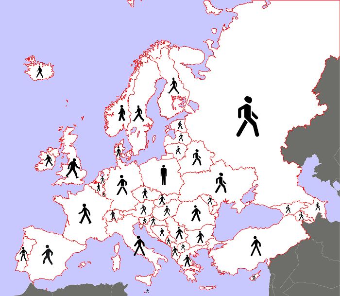
Image credits: 3OxenABunchofOnions
#2 Europe Number Plates
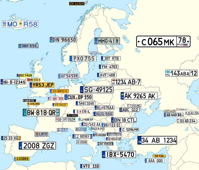
Image credits: reddit.com
#3 ‘October’ In European Languages
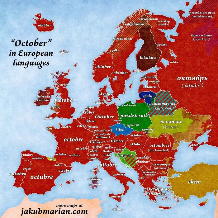
Image credits: reddit.com
#4 How To Say “Thank You” In Europe
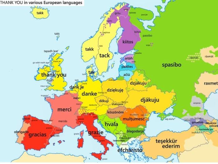
Image credits: reddit.com
#5 Tracking Of An Eagle Over A 20 Year Period
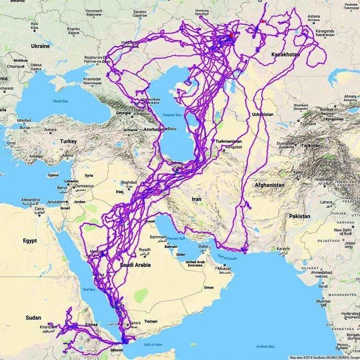
Image credits: HDeo950
#6 The Topologist’s Map Of The World – A Map Showing International Borders, And Nothing Else
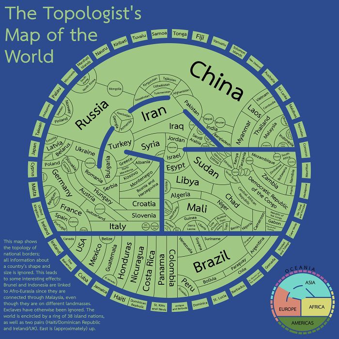
Image credits: xilefakamot
#7 An Image Of GPS Tracking Of Multiple Wolves In Six Different Packs Around Voyageurs National Park Shows How Much The Wolf Packs Avoid Each Other’s Range

Image credits: john3806
#8 Passenger Railway Network 2020
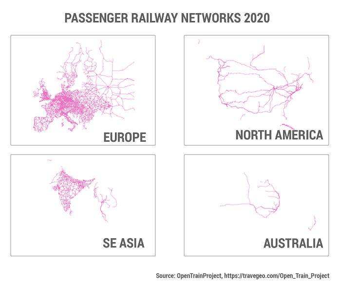
Image credits: TraveGeo
#9 The Earth Being Centered On Great Britain Is Arbitrary, So Here’s A Map Centered On New Zealand
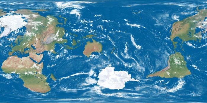
Image credits: ParadoxicalCabbage
#10 My Teacher Was Excited For Our WWI Unit
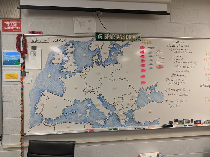
Image credits: Toylot5
#11 The Surface Of Mars: If, Like Earth, 71% Of Its Surface Area Was Covered With Water
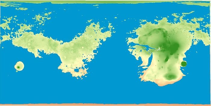
Image credits: crukey
#12 The United States Of America: Alaskan Perspective
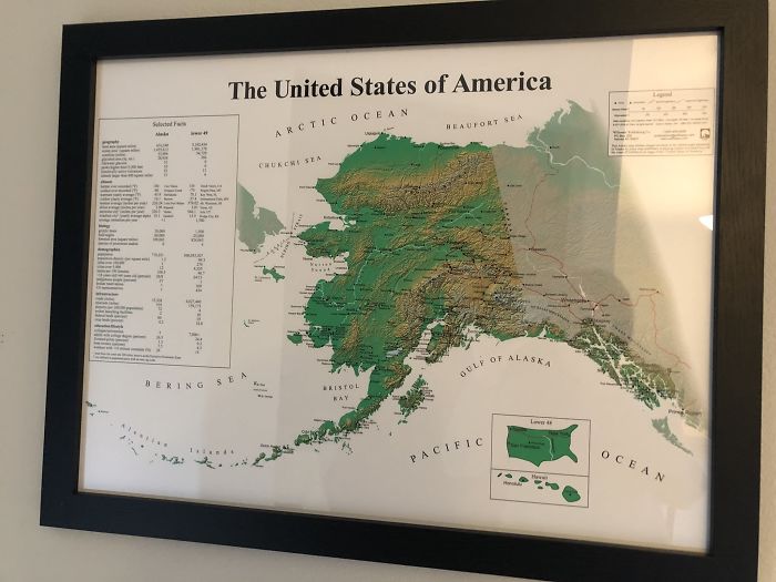
Image credits: Pariahdog119
#13 The Surprising Range Of Flamingos
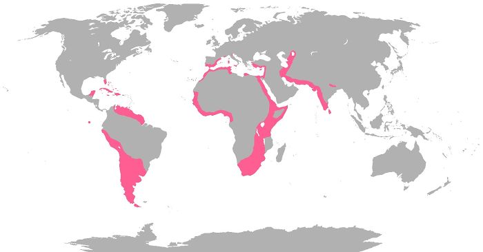
Image credits: CountZapolai
#14 These Two Areas Of Africa Have Roughly Equal Populations
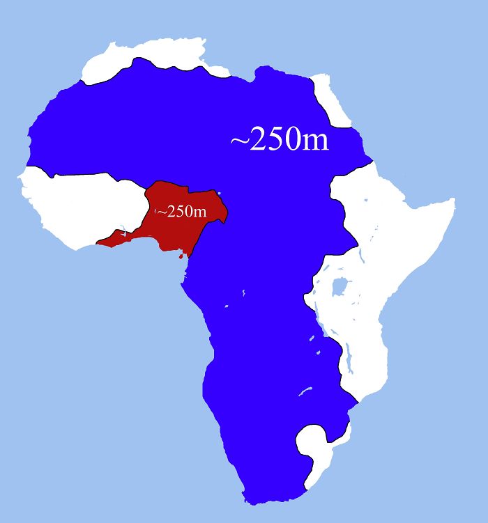
Image credits: LlNES653
#15 Locations Johnny Cash Claims To Have Been In “Ive Been Everywhere”
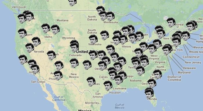
Image credits: DaTingGoesSkraaa
#16 To Increase Local Tourism, Lithuania Has Made A Map With Magnets That You Can Only Find In Corresponding Cities
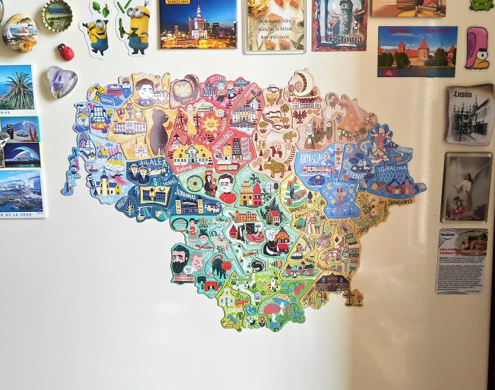
Image credits: greycoconut
#17 When A Band Announces A World Tour
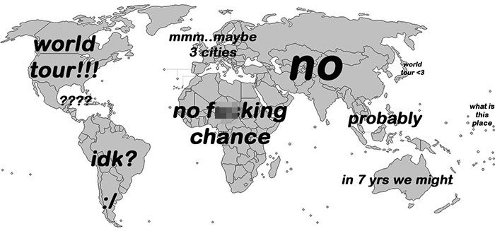
Image credits: esloubro
#18 List Of Countries Mentioned Or Referred In The Bible

Image credits: Erik_John09
#19 World’s 25 Largest Lakes Side By Side

Image credits: TWWILD_
#20 The Longest Possible Train Travel In The World
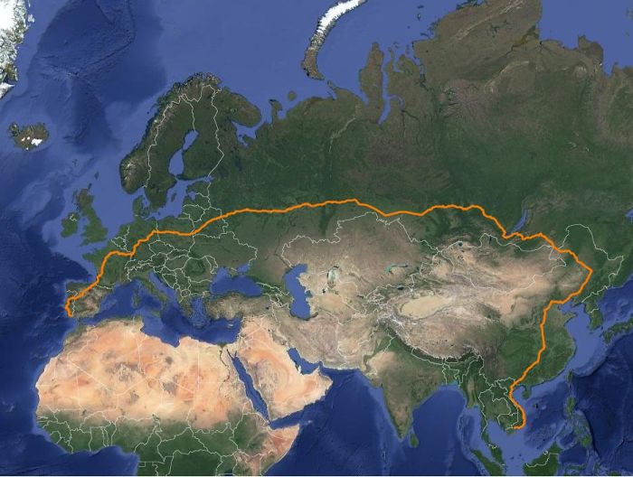
Image credits: matias90
#21 How Much Snow Does It Usually Take To Cancel Schools?
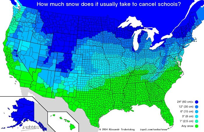
Image credits: etymologynerd
#22 The Japanese Flag But The Two Colors Have The Same Population
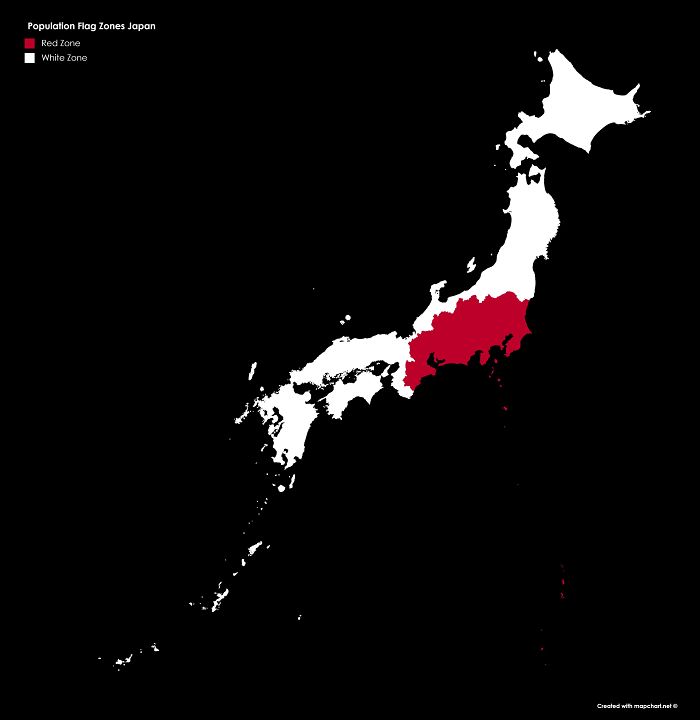
Image credits: LordPhoenix99
#23 Usage Of ‘Dang’ In The United States
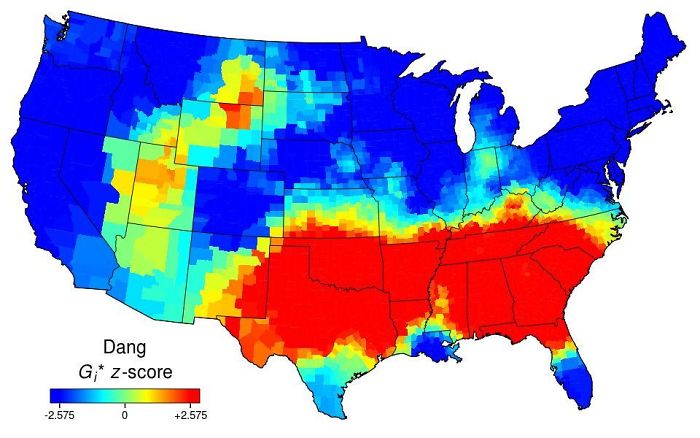
Image credits: AJgloe
#24 Roads Either Side Of The Border: Finland vs. Russia
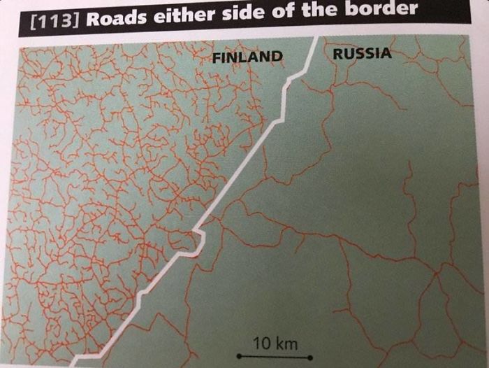
Image credits: AJgloe
#25 World’s Smallest Country vs. Largest Building
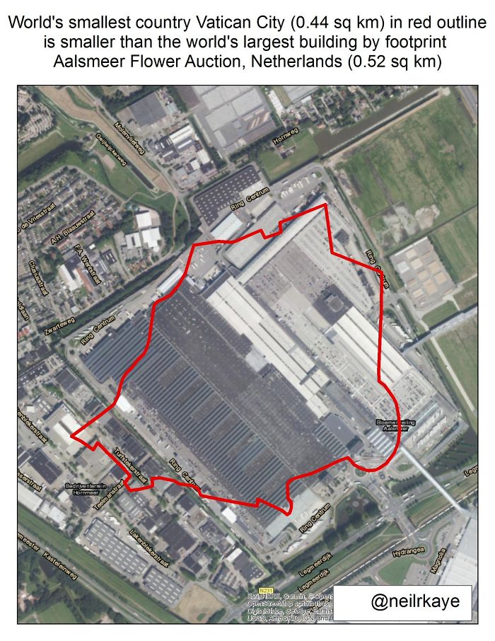
Image credits: neilrkaye
#26 Where Penguins Are Found Naturally In The World
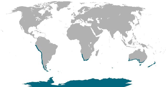
Image credits: cheeseface35
#27 A Map Of The World But It’s Just The Time Zones
Image credits: H501
#28 Percentage Of People Willing To Fight For Their Country
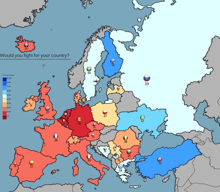
Image credits: kemppis
#29 Worlds CO Emissions
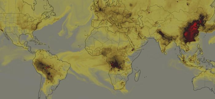
Image credits: reddit.com
#30 Variations Of The Name John
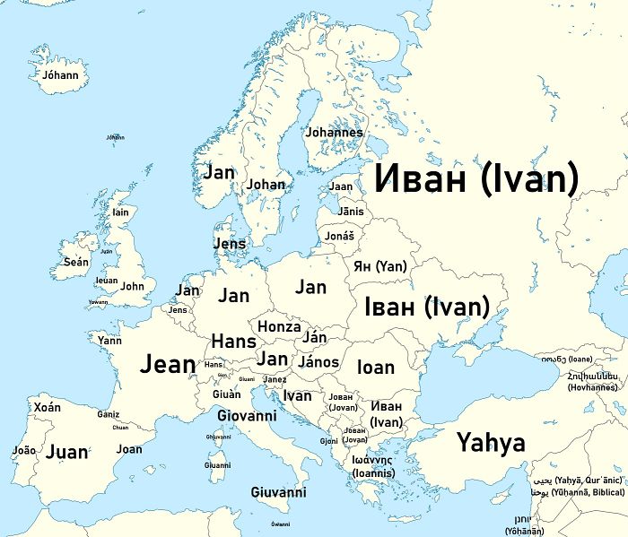
Image credits: _1_2_3_4_3_2_1_
#31 How The Antarctic Looks Beneath The Ice
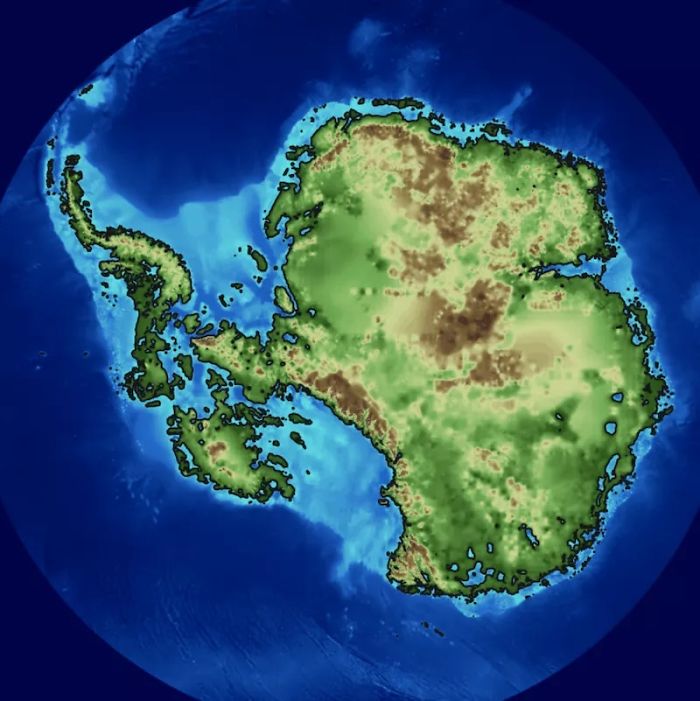
Image credits: reddit.com
#32 3D Render Topographic Map Of Europe
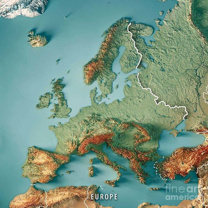
Image credits: reddit.com
#33 Coats Of Arms Of European Countries
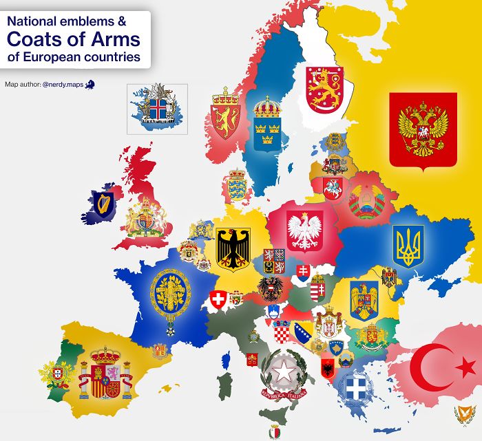
Image credits: reddit.com
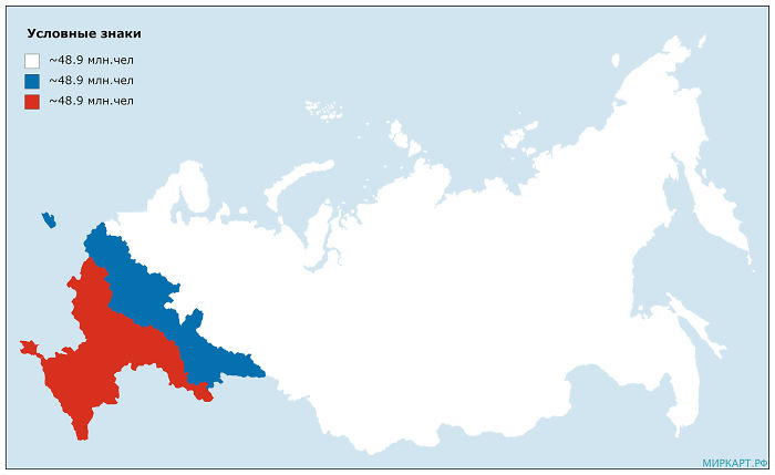
#34 The Russian Flag But The Two Colors Have The Same Population
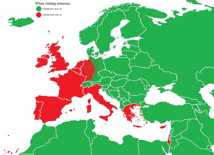
#35 When Visiting Someone: Red – Keep Shoes On, Green – Take Shoes Off
#36 What Motorcycles Look Like Across Europe (Based On The Prohibitory Road Sign)
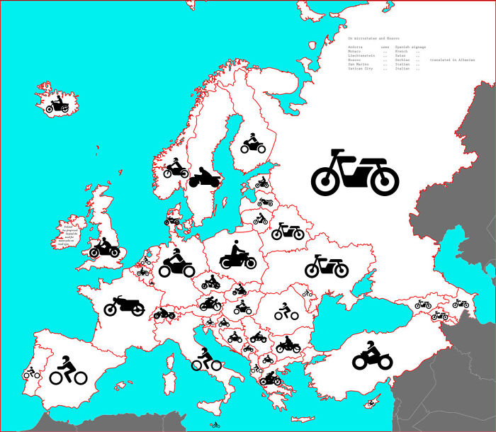
Image credits: 3OxenABunchofOnions
#37 Frances Longest Border Is Shared With Brazil!

Image credits: slamfist69
#38 A Europe–U.S. Superhighway Proposed By The Former President Of Russian Railways
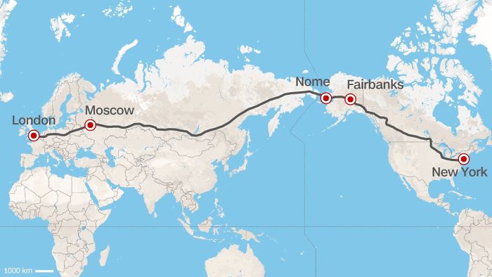
Image credits: emilylikesredditalot
#39 Brazil’s Northernmost Point Is Closer To Every Country In The Americas Than To Brazil’s Southernmost Point
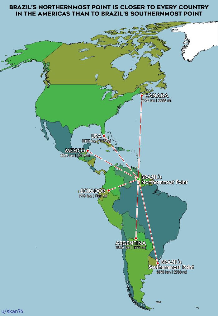
Image credits: skan76
#40 The Nearest Country To Everywhere In The US
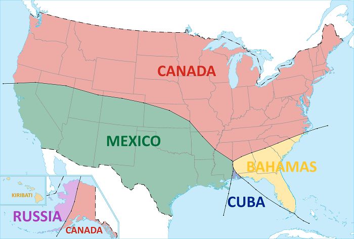
Image credits: e8odie
#41 All The Nations That Have To Be Combined To Be Equal To Brazils Annual Homicides

Image credits: Arnmaran
#42 Hundred Largest Islands Of The World
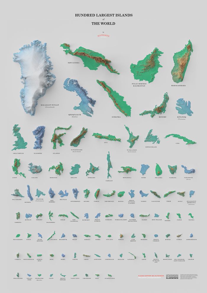
Image credits: mapmakerdavid
#43 90 Minute Public Transit Commuter Zone For London vs. San Francisco
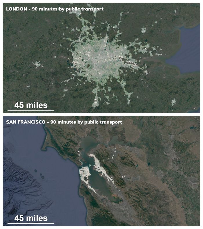
Image credits: tzfld
#44 The Countries That Got Tea Via China Through The Silk Road (Land) Referred To It In Various Forms Of The Word “Cha”. On The Other Hand, The Countries That Traded With China Via Sea – Through The Min Tan Port Called It In Different Forms Of “Te”
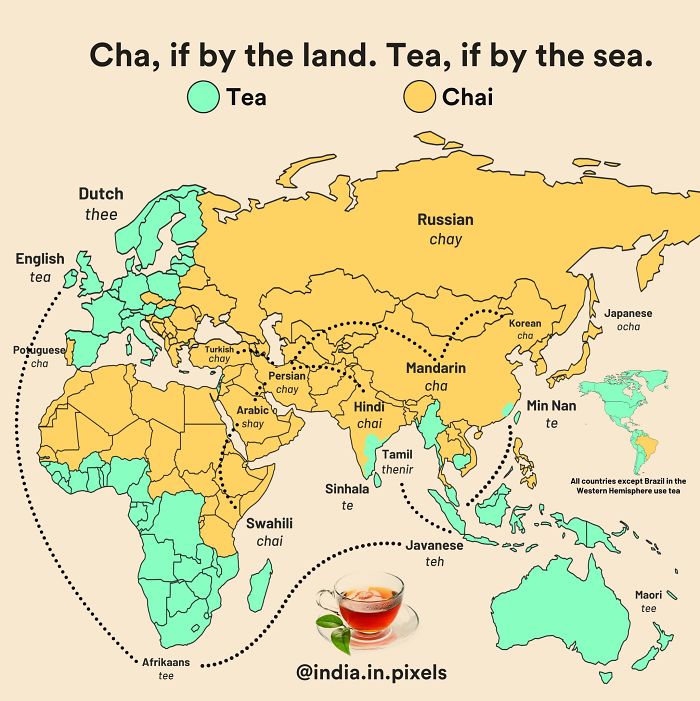
Image credits: reddit.com
#45 How To Become President With 22% Of The Vote
If you would get 50.1% of the vote of each red-coloured state, 22% of the population of the country, you would become president, even if 78% of the country voted for another person, this is assuming that 49.9% of people in the the red-coloured states voted for the blue party, and 100% of the people in the blue-coloured states voted for the blue party.
NOTE: The colours dont mean anything
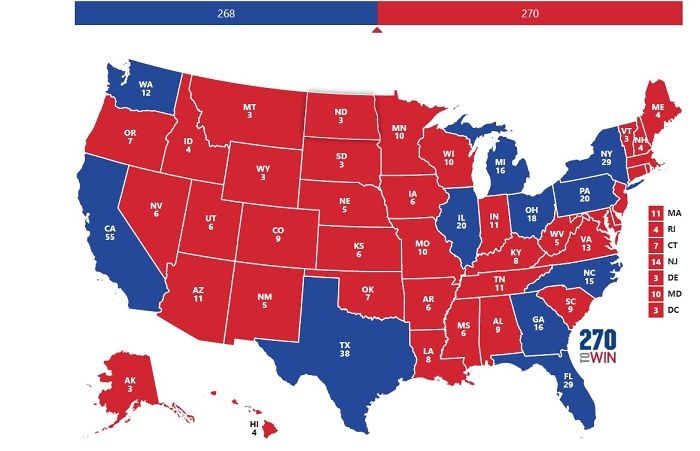
Image credits: persondotcom_idunno
#46 The History Of Accuracy In World Maps
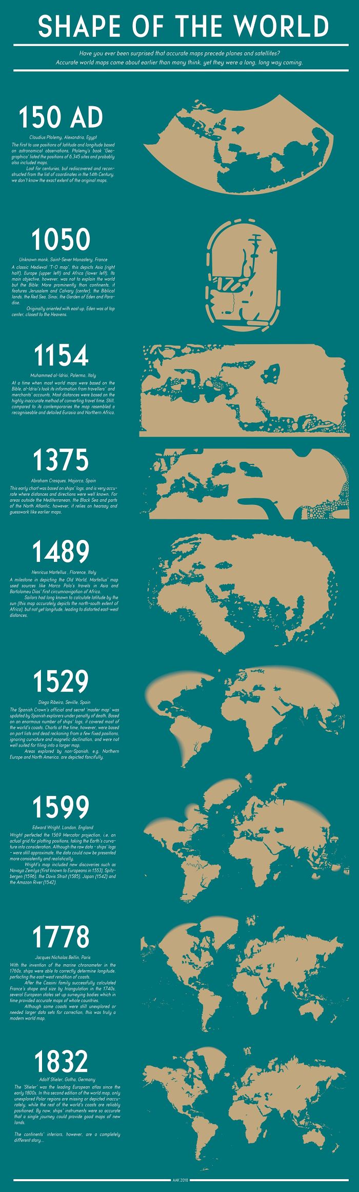
Image credits: PisseGuri82
#47 Each Section Has 10% Of The World’s Population
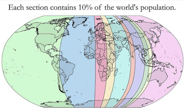
Image credits: AppleBiryani
#48 50 Percent Of Canadians Live South Of The Red Line
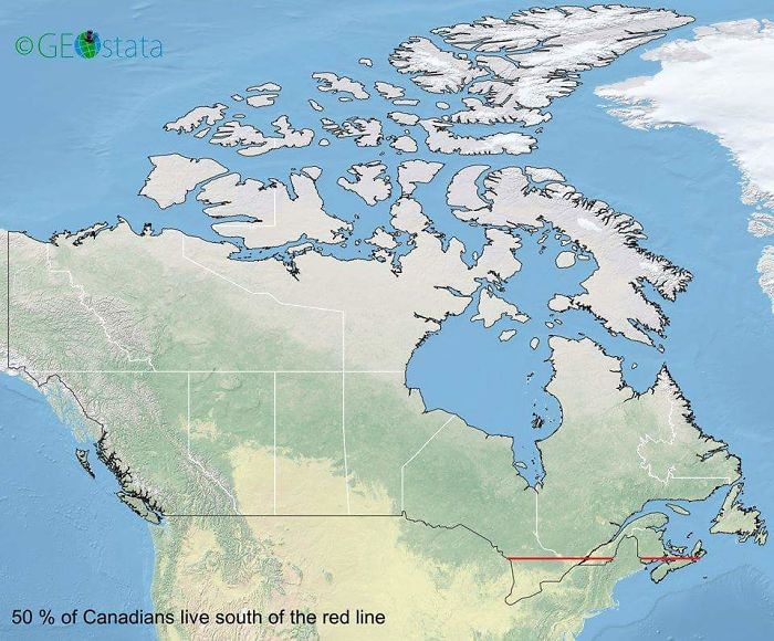
Image credits: midlleeastcelts
#49 Comparing The Population Of The Dakotas And Manhattan
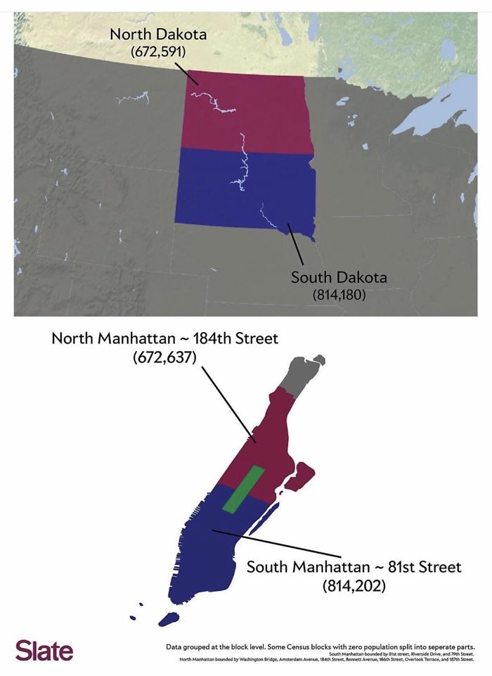
Image credits: michaelclas
#50 Occupied Bald Eagle Nests In Wisconsin. 1974 vs. 2019. Growth Credited To The Clean Water Act
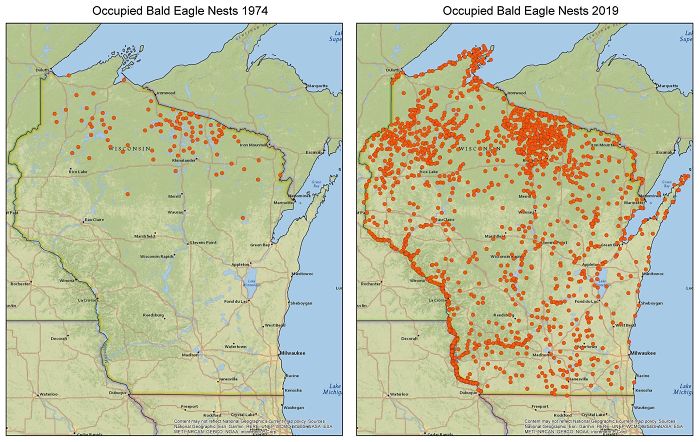
Image credits: zstahowiak
#51 British Columbia Split Into 3 Areas Of Equal Population

Image credits: jakemillionstv
#52 The Decline Of Our Native Tongue Over The Last 2 Centuries, I Find The Maps Rather Than The Reciting Of Statistics, Gives A Far Better Impression On The Overall Erosion Of One Of The Biggest Aspects Of Our Culture, Irish Itself

Image credits: dumbcrow123
#53 Japan, How Big It Is In Reality?
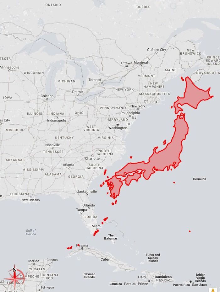
Image credits: c0urso
#54 Map Of Venus If It Has As Much Water As Earth

Image credits: Dragonite-2
#55 Paper Sizes World Map
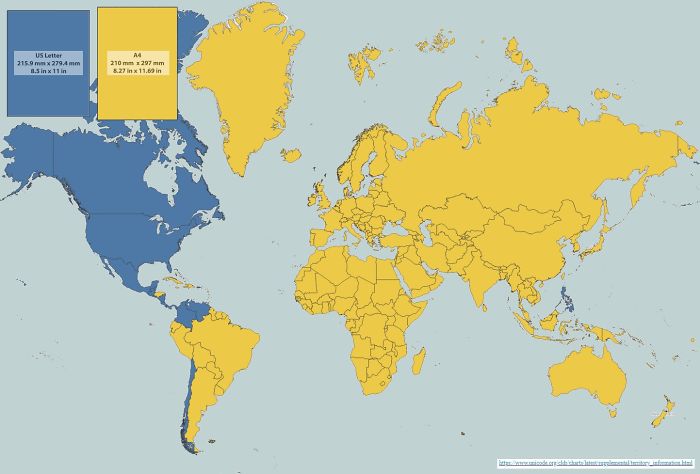
Image credits: JurijFedorov
#56 Turkey , Borders 7 Countries With 7 Different Alphabets
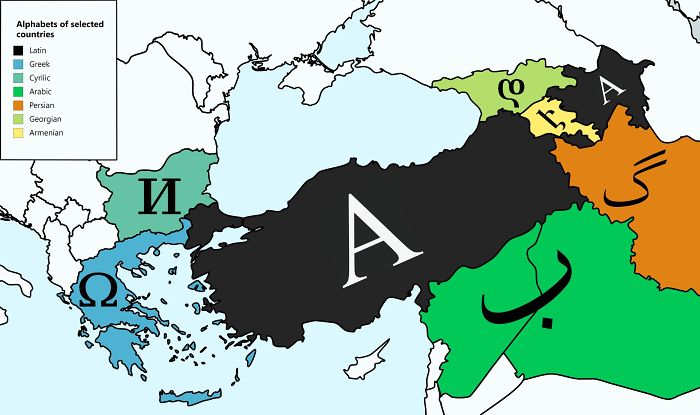
Image credits: philophobist
#57 World With 1000m Sea Level Drop
Image credits: BasedMaps
#58 Position Of The North Magnetic Pole Since 1590
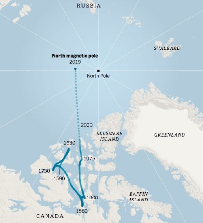
Image credits: RedGolpe
#59 Size Comparison Between Australia And The United States
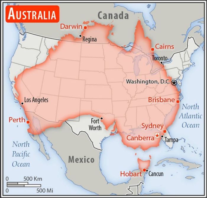
Image credits: AJgloe
#60 Cheese Map Of Europe
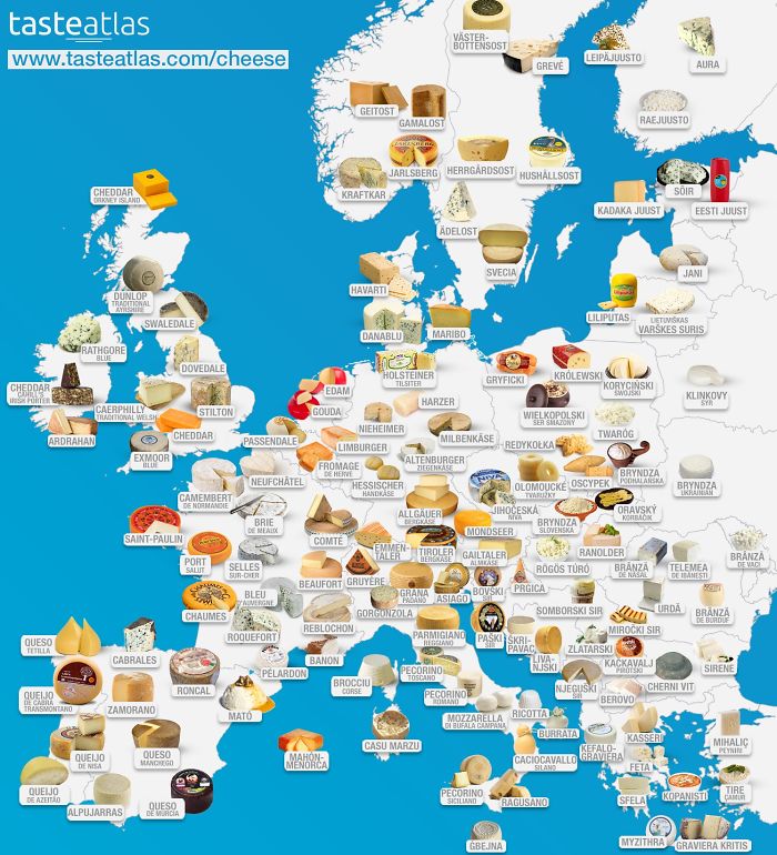
Image credits: dazzledvulture
#61 New Take On The Concept Of A World Metro
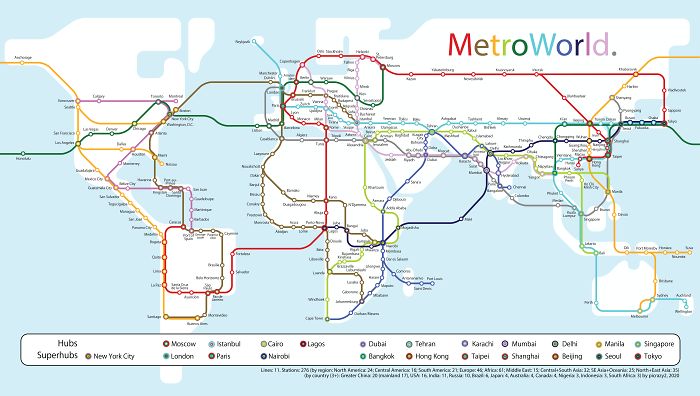
Image credits: picrazy2
#62 Average ‘First Leaf’ Appearance In The Contiguous U.S.
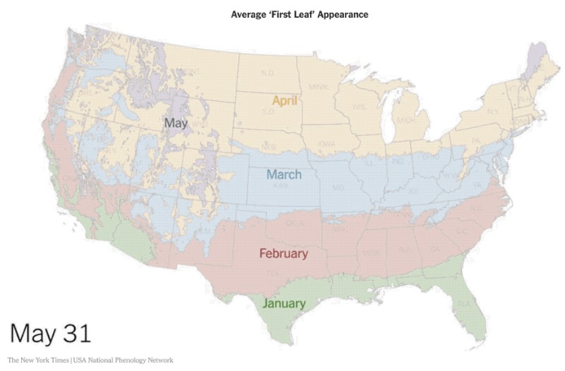
Image credits: Tranquil-Golden-Hour
#63 Map Of Almost All Countries And Their Respective Camo Patterns
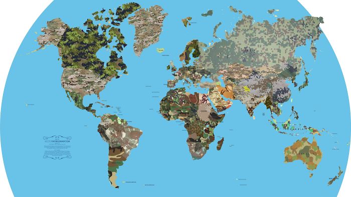
Image credits: The_Kadj
#64 The Italian Flag, But Every Colour Has The Same Population
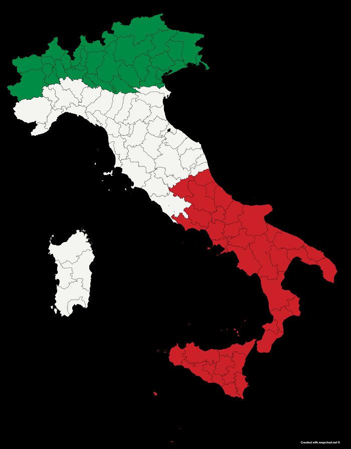
Image credits: 3OxenABunchofOnions
#65 North American Cryptids
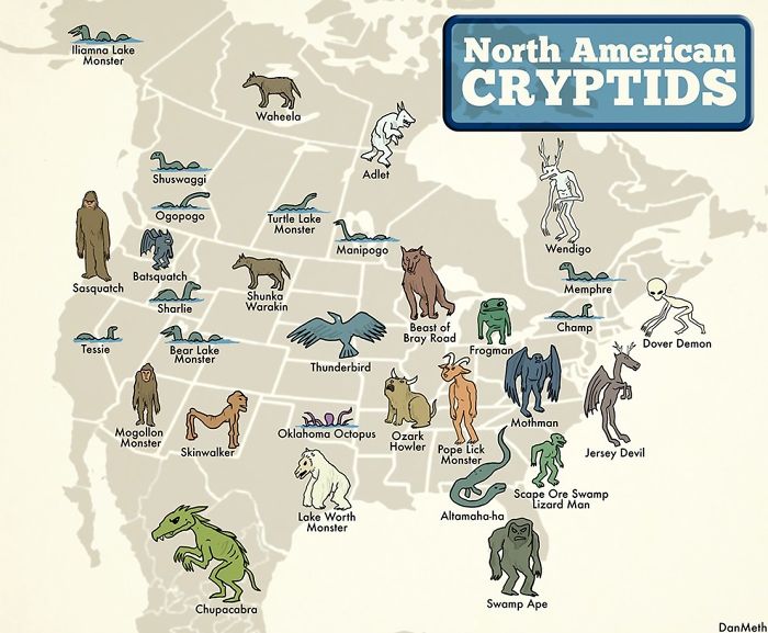
Image credits: reddit.com
#66 The Nearest Country To You, When In Russia
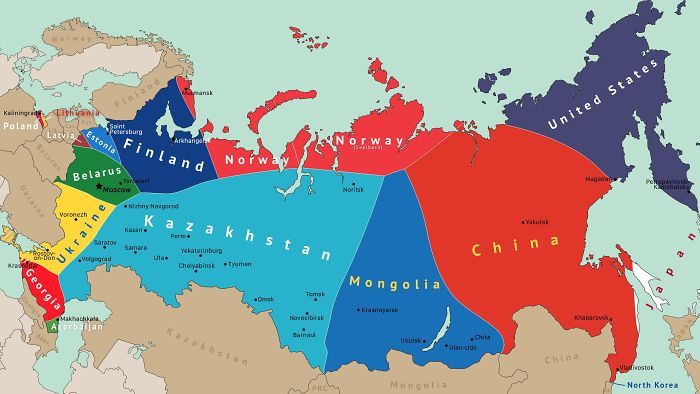
Image credits: reddit.com
#67 North America Animal Migration Routes
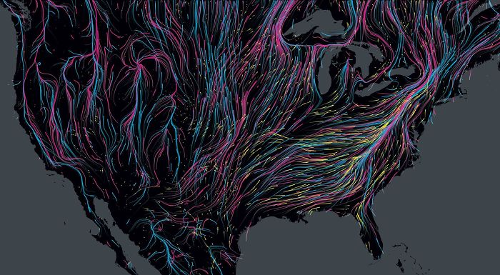
Image credits: expatdoctor
#68 There And Back Again
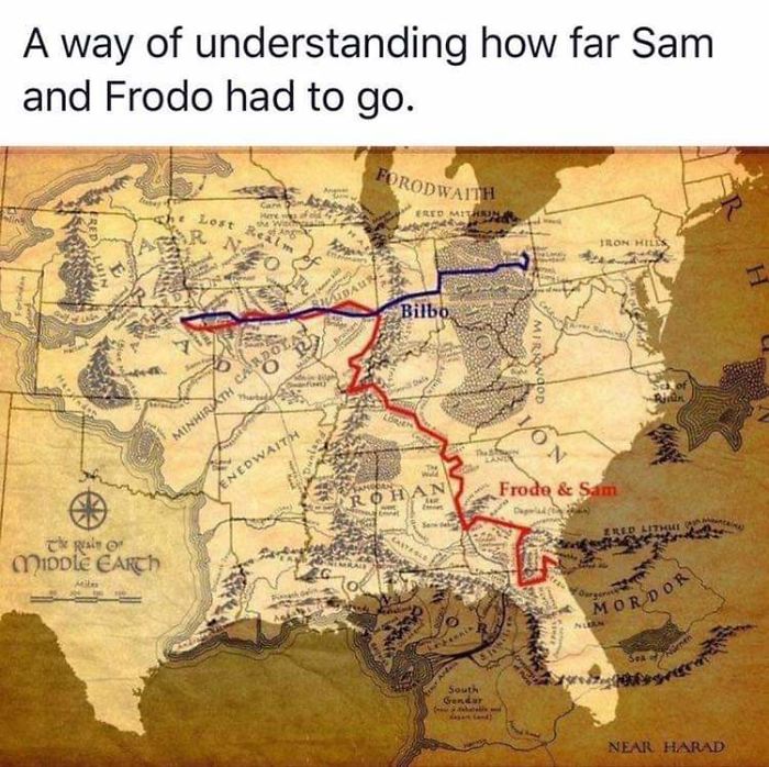
Image credits: tildenpark
#69 How I, A Brit, See The United States (Sorry If It Offends Anyone)
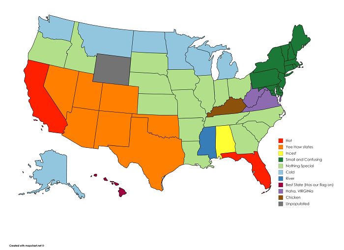
Image credits: DavidMcFarlanee
#70 4 Years Of Trucking, Each Dot Is Somewhere He Spent >1 Hour
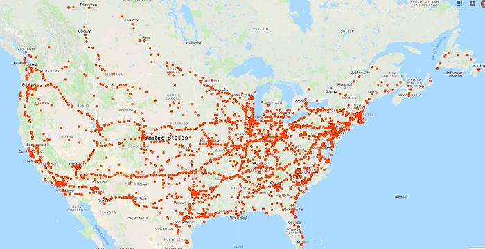
Image credits: reddit.com
#71 I Recorded The Last Two Months As A Pizza Delivery Guy (On Bike)
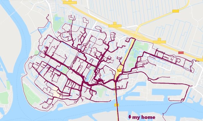
Image credits: Yordrecht
#72 Syria Before And After Civil War
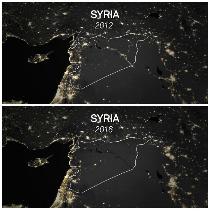
Image credits: atharva321
#73 You Can Fit The Entirety Of Poland Into Texas And Still Be Able To Drive Around It
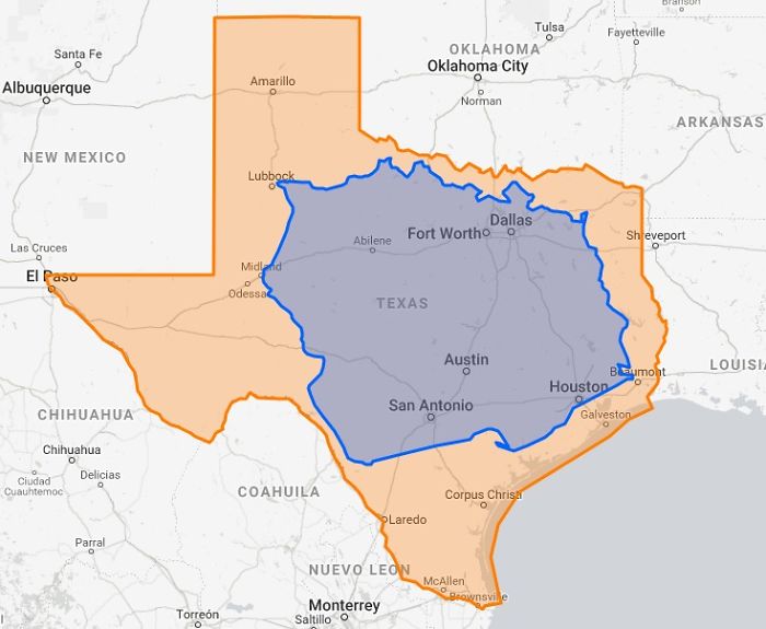
Image credits: ChetWinston
#74 Olympus Mons Compared To France
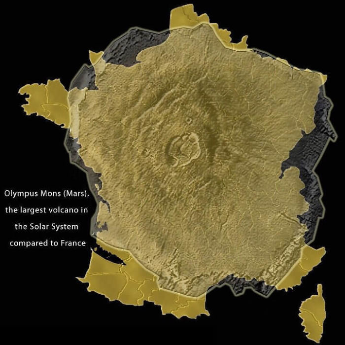
Image credits: ComradeUlyanov
#75 Amount Of Tanks Per 100 000 People

Image credits: From_The_Sun
Leave a Reply